A winter storm is set to impact the New York City metro area this Sunday, January 21, bringing significant snowfall. A winter storm watch has been issued for northeastern New Jersey, the Hudson Valley, and Fairfield County in Connecticut as temperatures are expected to drop below freezing.
- Warm temperatures expected Saturday with light rain.
- Afternoon showers will precede evening clearing.
- Winter storm watch issued for Sunday.
- Anticipate 3 to 8 inches of snow.
- Cold temperatures follow, lasting into next week.
- January is typically the coldest month.
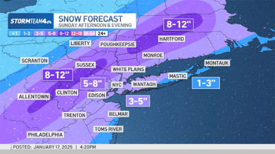
Snow will begin before noon on Sunday and continue into the evening, with accumulations varying across regions. The forecast predicts 3 to 5 inches in New York City and higher amounts further inland.
The upcoming winter weather event will start with rain on Saturday, January 20, primarily during the afternoon hours. Most areas can expect light rain totaling less than a tenth of an inch; however, eastern Long Island may see slightly heavier precipitation between a tenth and a quarter of an inch. This rain will not have a significant impact but could require an umbrella or rain jacket for outdoor activities.
On Sunday, snow is anticipated as colder air moves into the region. The transition from rain to snow may occur along the Jersey Coast and eastern Long Island due to milder initial temperatures. As conditions cool down throughout the day, most locations will experience all-snow events with accumulations that vary by location:
- New York City: 3 to 5 inches
- Northern New Jersey & Upper Hudson Valley: 5 to 8 inches
- Higher elevations in northwest New Jersey: up to a foot of snow
The snow is projected to taper off after midnight on Monday morning. Following this storm system, temperatures are expected to plummet into the teens and twenties next week, with morning lows potentially reaching single digits in Central Park. This period marks one of the coldest times of year climatically for the region.
This weekend’s weather highlights a stark contrast between mild conditions on Saturday followed by significant snowfall on Sunday. Residents should be prepared for travel disruptions due to accumulating snow and dress appropriately for frigid temperatures in the days following.


