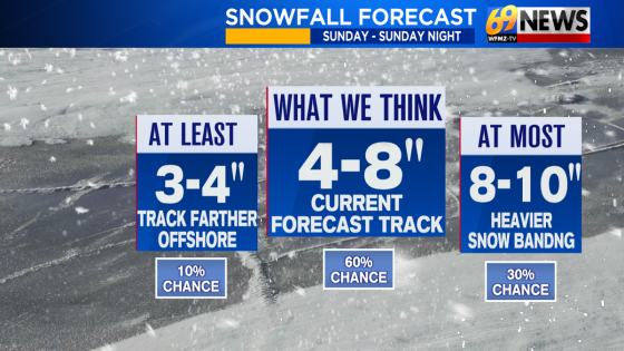
A significant snowfall is expected on Sunday, January 21, 2025, with forecasts predicting 4 to 8 inches of snow across much of the area. The storm’s track has shifted closer to the coast, increasing confidence in a steadier snowfall for residents.
- 4-8 inches of snow expected Sunday
- Confidence in snowfall forecast has increased
- Snowfall timing: 10 AM to 10 PM
- Bitter cold temperatures following the storm
- Wind chills could reach -10 to -20 degrees
- Powdery snow with potential for drifting
This winter event will begin by mid to late Sunday morning and is anticipated to taper off before midnight. Bitterly cold temperatures will follow, with wind chills dropping as low as 20 degrees below zero.
The upcoming winter storm is being closely monitored as it approaches on Sunday. Initially predicted to deliver between 3-6 inches of snow, forecasts have now been adjusted due to increased confidence in a stronger system. Key details include:
- Snowfall amounts are expected to range from 4-8 inches.
- Heavier bands may produce isolated totals exceeding 9 or even 10 inches.
- The snow type will be powdery due to colder temperatures.
Snow is projected to develop around mid-morning and intensify during the afternoon and early evening hours. The heaviest snowfall is likely from approximately noon until early evening before tapering off around midnight. As winds pick up later that night into Monday and Tuesday, conditions may lead to blowing and drifting snow.
Temperatures are forecasted to drop through the 20s during snowfall on Sunday afternoon and then into the teens overnight. Wind gusts could reach up to 25 mph, resulting in dangerous wind chill factors that could feel like -10 to -20 degrees Fahrenheit at times through Thursday morning.
This winter storm represents one of the most significant weather events so far this season. Residents are advised to stay updated on local forecasts and prepare for hazardous travel conditions due to heavy snowfall and extreme cold following the storm’s passage.