As the Arctic front arrives in Houston on Saturday, residents are bracing for significant weather changes. This cold front will bring a shift in temperatures, making it essential for everyone to prepare for the chilly days ahead.
- Tonight's temperatures are warmer with gusty winds.
- Light rain showers expected across SE Texas.
- Arctic cold front arrives Saturday morning.
- Houston Marathon will face strong headwinds.
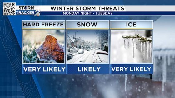
- Dangerous weather from Monday night to Tuesday.
- Prepare for freeze: protect plants and pets.
With the Houston Marathon taking place this Sunday, how will the weather impact participants? Let’s dive into the forecast and what you need to know.
Houston’s Weather Alert: Cold Front and Wintry Conditions Ahead
Are you ready for the upcoming cold front? As temperatures drop, it’s crucial to stay informed about the weather changes. The Arctic air will begin to affect Houston starting Saturday morning, bringing colder temperatures and potential wintry weather into early next week.
What to Expect: Cold Front and Marathon Weather in Houston
The Houston Marathon is set for this Sunday, and with temperatures starting in the mid-30s, runners need to be cautious. Here’s what to prepare for:
- Wind chills will make it feel like the upper-20s at the start.
- Temperatures will rise to the lower-40s as the morning progresses.
- Strong winds from the north at 15 mph will create challenging conditions for runners.
- Expect a headwind for those running the half and full marathon.
Preparing for the Cold: Tips for Residents and Runners
As the cold front approaches, it’s essential to take precautions. Here are some tips to help you prepare:
- Bring in or cover outdoor plants to prevent damage from freezing temperatures.
- Ensure pets are indoors and comfortable during the cold snap.
- Check your pipes to avoid freezing and potential bursts.
- Consider winterizing your sprinkler system to prevent damage.
Forecast for Early Next Week: What You Need to Know
As we move into Monday and Tuesday, temperatures are expected to drop significantly. Here’s what to anticipate:
- Monday night temperatures may fall below freezing, creating icy conditions.
- Rain, sleet, and potentially snow will affect areas mainly north of I-10.
- Roads may become hazardous due to ice and snow accumulation.
- Wednesday afternoon will bring a thaw, but icy roads may linger.
Stay tuned for updates as the weather evolves. It’s crucial to stay informed and prepared for the cold front and its potential impacts.