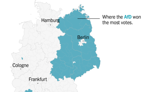
Two winter storms are set to impact the Midwest and Northeast regions of the united states, beginning Wednesday, February 5. The first storm, named Winter Storm Freya by The Weather Channel, is expected to bring significant snow and ice, creating hazardous travel conditions across these areas.
- Winter Storm Freya impacts Midwest and Northeast.
- Hazardous travel due to snow and ice.
- First storm arrives Wednesday into Thursday.
- Second storm expected Saturday-Sunday.
- Active winter pattern may continue next week.
- Monitor updates on weather.com for details.
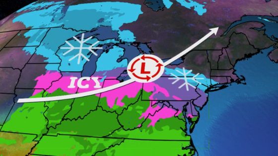
The upcoming winter storms are poised to affect a wide swath of the Midwest and Northeast. The first system will move in from Wednesday into Thursday, bringing a mix of freezing rain, sleet, and snow. Areas such as northern Missouri, Iowa, Chicago, Cleveland, and Detroit may experience hazardous travel conditions due to icing on roads.
Key details include:
- Freezing rain and sleet developing in northern Missouri before spreading eastward.
- The best chance for all-snow precipitation lies in central Minnesota and northern Michigan.
- Pockets of significant icing could occur in central Pennsylvania.
The second storm is expected over the weekend with similar impacts. Snow is likely from the upper Midwest through parts of the mid-Atlantic region. The Interstate 95 corridor may see initial snowfall that transitions into a wintry mix or rain later on Saturday. This system is projected to move quickly out by Sunday morning.
Long-term forecasts suggest that this active winter weather pattern might continue into next week with further chances for snow and ice across affected regions. Residents should stay updated via local weather services for any changes in forecasts as conditions develop.
The Midwest and Northeast are bracing for two consecutive winter storms that could lead to dangerous travel situations due to icy roads and mixed precipitation. As these systems unfold over the coming days, monitoring updates will be crucial for safety precautions during this active weather period.