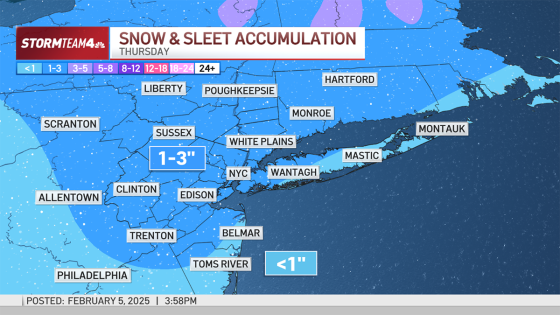
A winter weather advisory was issued for the tri-state area on February 6, 2025, as snow, sleet, ice, and rain are expected to disrupt the morning commute. The advisory excludes eastern Suffolk County on Long Island and areas along the Jersey Shore.
- Winter weather advisory in effect for tri-state area
- Morning commute impacted by snow and sleet
- Ice accumulation expected, but not catastrophic
- Hudson Valley to see mostly snow
- Evening commute will be quieter, but slick
- More winter weather systems expected this weekend
The winter storm system is set to begin affecting the New York City metro area during the pre-dawn hours of Thursday. Initially, light snow will fall across most regions but will transition to sleet and freezing rain as warmer air moves in later in the morning. This changeover will vary by location; South Jersey may see a quicker switch to all rain by sunrise while North and Central Jersey could experience icy conditions during peak commute times.
Key details include:
- Snow accumulation of 1-2 inches expected across much of New Jersey and parts of NYC.
- Icing amounts will be minor but can still create hazardous travel conditions.
- Temperatures are predicted to rise above freezing by late morning, leading to slushy roads.
The Hudson Valley region is likely to see mostly snow with minimal transitions to rain. By late morning, any remaining precipitation should clear up significantly. As temperatures drop again in the evening, some areas might experience slick or icy patches due to refreezing from earlier snowmelt. Following this event, another wintry system is forecasted over the weekend.
This winter weather advisory highlights potential challenges for commuters across the tri-state area on Thursday morning. While significant snowfall is not expected, even light icing can lead to dangerous travel situations. Residents are advised to plan accordingly as they navigate their routes during this messy weather event.