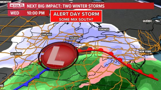
A major winter storm is set to impact Ohio and Michigan from Wednesday night into Thursday, bringing significant snowfall and icy conditions. An ALERT DAY has been issued as the storm system approaches, with forecasts indicating it could deliver the largest snowfall of the winter season so far.
- Significant snowfall expected this week.
- ALERT DAY issued for Wednesday night.
- Travel disruptions likely on Thursday morning.
- Prepare for potential school delays and closings.
- Monitor WTOL 11 for storm updates.
- Equip vehicles with winter storm essentials.
The weather pattern will remain dry on Monday before a storm system brings accumulating snow to southern regions on Tuesday. While this initial system will miss Toledo, a strong low-pressure system is expected to arrive late Wednesday evening, leading to snow beginning between sunset and midnight. The Toledo metro area can expect overnight snow with mixed precipitation possible further south.
Travel conditions are likely to deteriorate late Wednesday as roads become slippery from accumulating snow and ice. Forecasts suggest that regardless of accumulation amounts, motorists should prepare for slow travel on Thursday morning. Areas northwest of the Maumee River are projected to receive the heaviest snowfall, which could lead to school delays or closures.
Residents are advised to stay updated with local forecasts throughout the week as conditions evolve. It’s recommended that anyone planning travel leave before sunset on Wednesday or postpone until Thursday afternoon when conditions improve. Essential items like blankets and an ice scraper should be kept in vehicles during this period.
This upcoming winter storm poses a significant risk for travel disruptions across Ohio and Michigan. With preparations underway and alerts issued, residents are encouraged to take necessary precautions ahead of time.