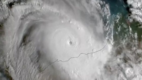
Tropical Cyclone Zelia made landfall on February 14, 2025, in northwestern Australia, bringing severe weather conditions to the region. The storm struck 34 miles northeast of Port Hedland, packing winds of 132 miles per hour, comparable to a Category 4 hurricane.
- Tropical Cyclone Zelia made landfall in Australia.
- Winds reached 132 mph, Category 4 hurricane.
- Residents ordered to stay indoors for safety.
- Major ports in Pilbara region closed.
- Heavy rain and flooding expected inland.
- Port Hedland likely to avoid severe damage.
The impact of Tropical Cyclone Zelia has raised concerns due to its potential effects on the Pilbara region, which is home to some of the world’s largest iron ore mines. The Bureau of Meteorology reported that the cyclone made landfall at 12:30 p.m. local time. Residents in Port Hedland and surrounding areas were advised to stay indoors as the storm approached.
Key details about the cyclone include:
- Wind speeds of 132 mph at landfall.
- Tropical cyclone warnings issued from Wallal Downs to Roebourne.
- Forecasted wind gusts of up to 180 mph near the storm’s eye.
Authorities closed schools and roads in anticipation of flooding and severe weather. Major ports in the region, including Port Hedland, Dampier Port, and the Port of Varanus Island, have also been closed to prepare for the storm’s impact. While Zelia is expected to weaken as it moves inland, heavy rain and strong winds are still anticipated in the coming days.
The situation remains fluid as Zelia continues its path inland, with authorities closely monitoring the storm’s progression and its effects on the critical infrastructure of the Pilbara region.


![[BREAKING] Fire erupts on Air Busan Plane at Gimhae Airport; All 176 onboard safely evacuated](https://news.faharas.net/wp-content/uploads/2025/01/Fire-Breaks-Out-on-Air-Busan-Flight-at-Gimhae-Airport-230x129.png)


