A Weather Impact Alert has been issued for Austin, Texas, as the region braces for the coldest air of the season from Tuesday night through Friday morning. The KVUE Weather Impact Team warns that low temperatures will lead to hard freezes during this period.
- Weather Impact Alert Days issued for next week
- Cold front arrives Tuesday afternoon
- Hard freeze expected Wednesday through Friday
- Dangerously low wind chill values anticipated
- Low chances of wintry precipitation in Central Texas
- Temperatures will warm next weekend
The forecast predicts temperatures in the teens and 20s, with dangerously low wind chill values potentially reaching single digits or below. Residents are advised to take precautions for people, pets, pipes, and plants due to these extreme conditions.
The arctic cold front is expected to arrive on Tuesday afternoon, dropping temperatures significantly from the upper 60s into the 30s almost immediately. Sustained north winds of 15 to 25 mph will accompany this drop, leading to dangerously low wind chill values starting Tuesday night.
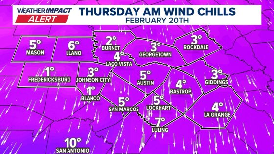
On Wednesday morning, a hard freeze is anticipated with air temperatures ranging from the upper teens to mid-20s across Central Texas. Wind chill values may fall into single digits or even lower. Thursday morning is projected to be even colder, with Austin hitting around 18 degrees—the lowest temperature recorded this winter.
- Tuesday: Highs near 70 before a rapid drop in temperature.
- Wednesday: Hard freeze with highs struggling above freezing; potential wind chills in single digits.
- Thursday: Coldest day predicted with widespread lows in the teens; afternoon warming slightly above freezing.
While there have been hints of light wintry precipitation early next week, current forecasts suggest that significant snow or ice impacts are unlikely. The KVUE Weather Team will continue monitoring conditions closely as they develop over the coming days.
This upcoming cold snap marks a significant weather event for Austin and surrounding areas. Residents should remain vigilant and prepared as temperatures plummet over several days, impacting daily activities and safety.