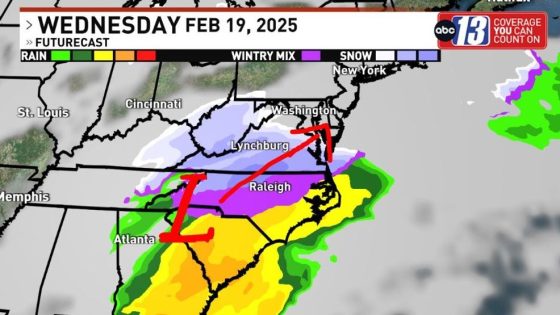
LYNCHBURG, Va. — A winter storm is expected to affect Virginia and surrounding areas on February 19 and 20, bringing significant snowfall. Weather experts anticipate a classic Nor’easter pattern that will impact the Carolinas, Virginia, Pennsylvania, and later New England.
- Classic winter storm expected next week.
- Snow likely to start Wednesday night.
- 12-18 hours of precipitation anticipated.
- Heaviest snow totals possible in SW to NE.
- Winter storm watches and warnings likely issued.
- Colder conditions with more snow than ice.
The upcoming winter storm is characterized by a cold front followed by a significant low-pressure system moving up from the south. This combination is expected to create ideal conditions for heavy snowfall across several states. The storm’s impact will begin with snow on Wednesday evening, continuing into Thursday morning.
Key details about the storm include:
- Snowfall expected to last for 12 to 18 hours once it begins.
- A transition to a wintry mix may occur as the snow tapers off.
- Forecasts suggest a swath of 10 inches or more could be seen across parts of Virginia and neighboring regions.
This event follows recent winter storms but is predicted to bring colder temperatures and more snow compared to previous occurrences. Winter storm watches and warnings are likely to be issued ahead of the event due to its potential severity, which may lead to school cancellations and disruptions at local airports.
The approaching winter storm poses significant implications for residents in affected areas. As preparations continue, authorities urge caution and readiness for potential disruptions caused by heavy snowfall.


![[RECULL FOTOGRÀFIC] La dignitat i el coratge de les víctimes que demanen la dimissió de Mazón - VilaWeb](https://news.faharas.net/wp-content/uploads/2025/02/Unyielding-Courage-Victims-Demand-Mazons-Resignation-in-Powerful-Photo-Recap-560x315.jpeg)