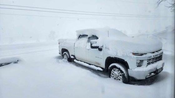
A winter storm is expected to impact Central New York (CNY) starting Saturday evening, February 16, 2025. Snowfall will transition to a wintry mix of sleet and freezing rain overnight, leading to hazardous travel conditions and potential power outages due to ice accumulation.
- Steady snow expected Saturday afternoon.
- Lighter snow overnight, minimal impact anticipated.
- Freezing rain concerns for northern areas.
- Strong winds may cause power outages.
- Flash freeze likely Sunday evening.
- Lake effect snow bands developing Monday.
The National Weather Service has issued alerts for the region as temperatures are forecasted to drop significantly on Sunday evening, exacerbating icy conditions on roads and sidewalks.
The weather system affecting CNY will bring a variety of precipitation types over the weekend. While steady snowfall began Saturday afternoon, it is predicted that the intensity will decrease through Saturday night. Most areas can expect an additional coating of up to two inches of snow or sleet before lighter precipitation takes over.
As the storm progresses into Sunday morning, heavier precipitation will arrive in different forms: rain in southern regions and a wintry mix of sleet and freezing rain along Route 5 and I-81 corridors. The combination of strong easterly winds and existing snowpack may lead to prolonged icing conditions particularly in Oswego and Oneida counties.
- Freezing rain may last longer in areas north of Route 31.
- Wind gusts between 40-60 MPH could result in downed power lines and trees.
- Temperatures are expected to fall quickly from the 30s into the 20s by Sunday evening.
Travelers should be prepared for rapidly changing road conditions as flash freezes could occur with falling temperatures. Accumulating lake effect snow is anticipated by Monday morning, particularly near major routes such as Thruway or Route 31 corridors. This could lead to significant snowfall accumulations depending on slight shifts in wind direction throughout the event.
This winter storm poses multiple challenges including icy travel conditions, potential power outages from ice accumulation, and rapidly changing weather patterns throughout Central New York. Residents are advised to stay informed about updates from local authorities as the situation develops.