SYRACUSE, N.Y. — A significant layer of ice is affecting Central New York (CNY) today due to freezing rain and sleet. Travel is strongly discouraged as hazardous conditions persist across the region on February 16, 2025.
- Avoid travel across Central New York today
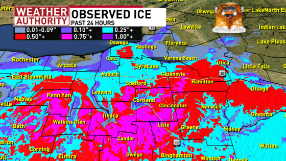
- Ice accumulation reported along the thruway
- Tornado and Severe Thunderstorm Watches issued
- Winter Storm Warnings in effect for CNY
- High Wind Warnings expected this evening
- Lake Effect Snow warnings for several feet
The current weather system impacting CNY is part of a larger storm affecting the entire East Coast of the united states. Tornado and Severe Thunderstorm Watches extend down to Florida, while wintry precipitation continues across the Northeast. In CNY specifically, areas south of the Thruway are seeing substantial ice buildup.
As of 10 AM this morning, Winter Storm Warnings and Weather Advisories have been issued for all of CNY due to expected ice and snow accumulation. The following details summarize current conditions:
- Ice accumulation: Significant thickness reported along major roadways.
- Snowfall: Expected primarily in northern regions such as Tug Hill and Northern Adirondacks.
- High Wind Warnings: Anticipated this evening could lead to power outages.
The transition from freezing rain to plain rain followed by snow will occur throughout the day. Lake-effect snow is forecasted to develop late Sunday night into early Monday morning, intensifying through Tuesday before tapering off Wednesday morning. Lake Effect Snow Warnings have been issued for several feet of snowfall in certain areas.
This winter storm presents serious challenges for travel and safety in Central New York today as residents prepare for worsening conditions later in the week. Authorities recommend staying informed through local forecasts and avoiding unnecessary travel until conditions improve.