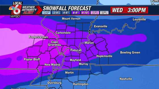
A winter storm watch is in effect from Tuesday morning through Wednesday morning across portions of southern Illinois, southwest Indiana, western Kentucky, and southeast Missouri. Heavy snow accumulations between 4 and 9 inches are expected, leading to hazardous travel conditions during the affected period.
- Winter storm watch from Tuesday to Wednesday.
- Heavy snow accumulations of 4 to 9 inches.
- Flood warnings for multiple Ohio River locations.
- Minor flooding ongoing at Paducah, Kentucky.
- Urban flooding reported along Clarks River.
- Travel advised against during hazardous conditions.
The National Weather Service has issued a winter storm watch that will last from Tuesday morning until Wednesday morning in several states including southern Illinois and western Kentucky. The anticipated heavy snowfall could make roads slick and hazardous, particularly impacting commutes on Tuesday morning and evening as well as Wednesday morning.
Key details include:
- Total snow accumulations of 4 to 9 inches possible.
- Roads may become difficult to navigate due to icy conditions.
- Dangerously cold temperatures are expected after the snow ends.
In addition to the winter storm threat, flood warnings have been extended for multiple rivers along the Ohio River. Moderate flooding is forecasted at locations such as Cairo, Evansville, and Owensboro with river levels expected to rise above flood stage. Current reports indicate minor flooding is already occurring along the Clarks River in western Kentucky due to excessive rainfall.
The combination of heavy snowfall followed by extreme cold poses significant risks for residents in the affected areas. It is advisable for individuals to monitor weather updates closely and avoid unnecessary travel during these hazardous conditions.