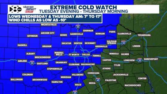
North Texans are preparing for the coldest air of the season as an Arctic front is expected to arrive on Tuesday afternoon, February 17, 2025. The region will experience dangerously low temperatures and wind chills that could drop below zero, prompting an extreme cold watch for many areas.
- Arctic front arrives Tuesday afternoon
- Dangerous cold expected midweek
- Light wintry mix possible overnight
- Wind chills could drop below zero
- Precautions needed for pipes and pets
- Warmer temperatures forecasted next weekend
The upcoming Arctic blast will significantly lower temperatures across North Texas. Following a weekend where highs reached 72°F, residents can expect a sharp decline in temperatures starting Tuesday evening. The National Weather Service has issued warnings for single-digit lows and wind chills that could reach as low as -10°F in some areas northwest of Fort Worth.
Key details include:
- An Arctic front arriving Tuesday afternoon.
- A potential light wintry mix from Tuesday night to Wednesday morning.
- Wind gusts up to 30 mph contributing to dangerous wind chills.
As temperatures plunge into the teens and single digits on Wednesday and Thursday mornings, precautions are advised to protect people, pets, pipes, and plants from freezing conditions. While Thursday may see slightly less wind, it will remain extremely cold with highs only reaching the mid-30s before warming Trends return later in the week.
This week’s forecast marks a significant shift in weather patterns for North Texas. Residents are urged to prepare adequately for these harsh conditions as warmer weather is expected to return next weekend.