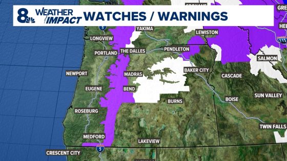
Heavy snow is forecasted for the Oregon Cascades from Sunday night through Monday afternoon, prompting a winter storm warning that will remain in effect until 4 p.m. on Monday. Up to two feet of snow are expected, with snow levels dropping to 3,500 feet.
- Heavy snow forecast for Oregon Cascades.
- Winter storm warning until 4 p.m. Monday.
- Up to two feet of snow expected.
- Travel over mountain passes challenging.
- Rain showers anticipated in the valley.
- Possible Weather Impact Alert for Wednesday.
The National Weather Service has issued a winter storm warning for the Oregon Cascades as heavy snowfall approaches the region. Meteorologist Joe Raineri indicates that mountain areas could see accumulations of up to two feet by Monday afternoon. Snow levels are set to drop significantly, creating hazardous conditions for travelers.
Travel over mountain passes may be particularly difficult due to heavy snow and potential freezing rain. Drivers are advised to exercise caution and consider postponing travel if possible. Key points include:
- Winter storm warning valid until 4 p.m. on Monday.
- Up to two feet of snow forecasted in mountainous regions.
- Freezing rain may complicate road conditions further.
In contrast, lower valley areas will experience rain showers tonight through tomorrow morning, though improvements in weather are predicted by Monday afternoon. Residents should prepare for wet conditions but can expect clearer skies later in the day. Looking ahead, another strong weather system could bring additional alerts mid-week with expectations of heavy rain and strong winds across the region.
This upcoming winter storm poses significant challenges for both residents and travelers in the Oregon Cascades area, emphasizing the need for preparedness as forecasts indicate severe weather impacts throughout this period.