A cold front is set to impact the Pyrenees this Saturday, bringing much-needed precipitation to the region. As we approach February 21, 2025, weather models indicate that this front could revitalize snowfall at higher altitudes and deliver rain to the mountain heads. Will this be the winter boost the Pyrenees have been waiting for?
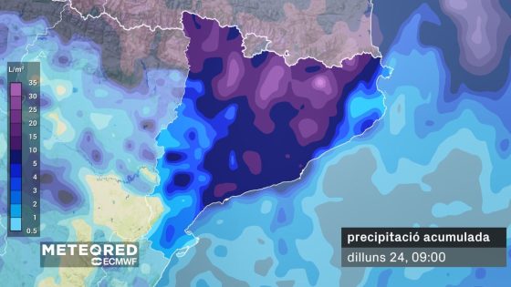
- Accumulated precipitation forecasted by ECMWF model.
- Cold front expected to impact Catalonia.
- Rain and snow predicted for the Pyrenees.
- Precipitation will increase from mid-morning.
- Snow accumulation over 15 centimeters expected.
- Sunday forecast shows more stable weather.
Cold Front to Bring Rain and Snow to the Pyrenees This Weekend
The upcoming cold front is generating excitement among winter sports fans and nature lovers alike. How will this weather change affect the snow conditions in the Pyrenees? With snow levels expected to drop and rain forecasted for the mountain heads, this could be a game-changer for the region.
Anticipated Precipitation and Snowfall in the Pyrenees
As the cold front approaches, the Pyrenees will experience varied precipitation patterns. Rain is expected to begin early Saturday, with heavier showers anticipated by midday. The snow level will start at around 1,800 meters, dropping to 1,600 meters by evening. This shift is crucial for the local environment and winter tourism.
What to Expect: Rain and Snow Accumulation Forecast
The weather models predict significant precipitation across the region. Here’s what to expect:
- Rainfall of 20 to 30 liters in the Ter-Llobregat basin.
- Snow accumulation between 10 and 25 centimeters at higher elevations.
- Snow levels decreasing throughout the day, enhancing ski conditions.
- Potential for increased river flows due to rain and melting snow.
Impact on Local Ecosystem and Winter Sports
This cold front is not just a weather event; it could have lasting impacts on the local ecosystem. The anticipated rain and snow will help replenish water sources, which have been low due to the dry winter. For winter sports enthusiasts, this is a welcome change, as improved snow conditions will enhance skiing and snowboarding experiences.
Looking Ahead: Stable Weather Expected After the Front
Following the cold front, Sunday is expected to bring more stable weather with plenty of sunshine. This transition will allow for clearer skies and enjoyable outdoor activities, making it an ideal time for visitors to explore the beautiful landscapes of the Pyrenees.
In conclusion, the impending cold front promises to deliver much-needed precipitation to the Pyrenees, revitalizing both the environment and winter sports activities. Keep an eye on the weather updates as this event unfolds!