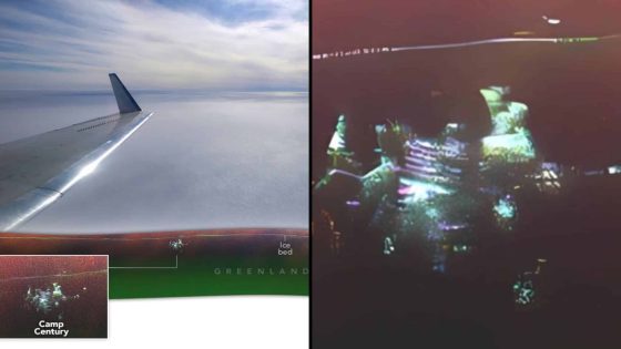
In April 2024, a team of scientists led by NASA’s Chad Greene discovered a Cold War-era facility beneath Greenland’s ice sheet while conducting research on ice thickness. The unexpected find, made using advanced UAVSAR radar technology, offers new insights into the ice sheet’s internal structure and its implications for climate change and sea level rise.
- NASA scientists discovered Cold War facility in Greenland.
- UAVSAR technology revealed detailed ice structures.
- Camp Century was buried since 1967.
- Research aids understanding of ice sheet dynamics.
- Findings impact future sea level rise projections.
- Climate change effects on ice behavior studied.
The mission aimed to map ice thickness and study the bedrock below the ice. Researchers, led by Alex Gardner from NASA’s Jet Propulsion Laboratory, were surprised when their radar signals detected an unusual structure. The facility, known as Camp Century, was established in 1959 as a secret military base and abandoned in 1967. It had remained buried under ice for decades until this recent discovery.
The UAVSAR radar system provided a detailed, three-dimensional view of the ice sheet, allowing scientists to capture sideways images of subsurface structures. Greene noted that the new data revealed individual structures of the hidden facility in unprecedented detail. This technological advancement opens new avenues for understanding ice sheet dynamics and the long-term effects of climate change.
Understanding ice sheet dynamics is crucial for assessing the impact of global warming on sea levels. The data collected from the Greenland mission is vital for predicting how ice will respond to warming oceans and atmosphere. Gardner emphasized that detailed knowledge of ice thickness is essential for accurate projections of sea level rise, linking the historical find to current climate research.
This discovery not only sheds light on a previously hidden military facility but also provides essential insights into the processes affecting the Greenland Ice Sheet, which plays a critical role in global sea level projections.


![[BREAKING] Fire erupts on Air Busan Plane at Gimhae Airport; All 176 onboard safely evacuated](https://news.faharas.net/wp-content/uploads/2025/01/Fire-Breaks-Out-on-Air-Busan-Flight-at-Gimhae-Airport-560x315.png)