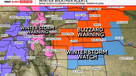
Blizzard warnings have been issued for portions of Colorado, particularly south and east of Denver, as a strong winter storm is expected to impact the area. The warnings will remain in effect at least through Tuesday afternoon, with treacherous travel conditions anticipated due to heavy snow and high winds.
- Blizzard warnings issued for eastern Colorado
- Treacherous travel expected overnight Monday
- High country to receive 4-10 inches of snow
- Strong winds up to 65 mph forecasted
- Slushy accumulation likely in Denver area
- Wind direction crucial for storm impact
The storm system moving into Colorado is predicted to bring significant snowfall across the region. In the high country, snow accumulations of 4-10 inches are likely throughout Monday. However, temperatures initially may be too warm for snow accumulation in Denver itself; only slushy conditions are expected downtown with minor accumulation possible in southern areas.
As the storm progresses overnight into Tuesday morning, high winds will exacerbate the situation. Wind gusts could reach up to 65 mph, leading to reduced visibility due to blowing snow on major highways such as I-70 and I-25. Travelers should prepare for potential delays or closures during the early morning commute.
- Blizzard warnings effective through Tuesday afternoon.
- Snowfall: 4-10 inches expected across higher elevations.
- Wind gusts: Up to 65 mph forecasted.
This weather event marks one of the first warm storms of the year for Colorado. As air rises during precipitation events, it cools down significantly which can lead to wetter and heavier snow types that complicate travel further. Residents are advised to stay updated on forecasts as conditions evolve over the coming days.
The upcoming winter storm poses serious risks for travelers in eastern Colorado due to blizzard conditions and strong winds. It is crucial for residents and commuters alike to remain vigilant and informed about changing weather circumstances as they develop over the next few days.