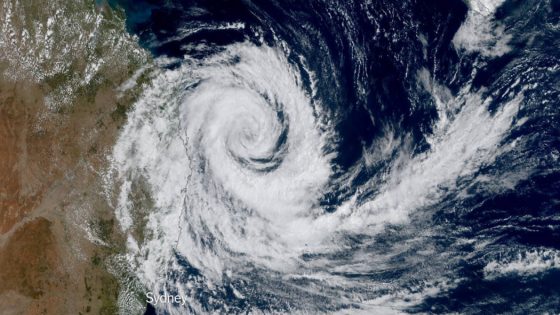
Australia‘s east coast is preparing for the impact of Tropical Cyclone Alfred, which is forecasted to make landfall later this week. The cyclone is expected to bring damaging winds, dangerous surf, and widespread flooding to parts of Queensland and northern New South Wales.
- Tropical Cyclone Alfred approaching Australia's east coast
- Unexpected westward shift in cyclone's path
- Tropical cyclone warning issued for affected areas
- Significant impacts expected before landfall
- Cyclone season in Australia runs November to April
- Dangerous sea conditions reported off Queensland coast
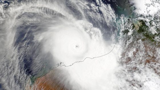
The Bureau of Meteorology indicated that the cyclone’s path has shifted unexpectedly, now targeting populated areas between Brisbane and the Sunshine Coast on Friday. This change was attributed to a high-pressure system to the south that altered its trajectory.
Tropical Cyclone Alfred has taken a surprising turn, prompting warnings from meteorologists. Initially expected to remain offshore, the cyclone is now on course to strike densely populated regions. The Bureau of Meteorology has issued a tropical cyclone warning from Double Island Point in Queensland to just north of Grafton in New South Wales, including major areas such as Brisbane, the Gold Coast, and Byron Bay.
Key details include:
- Alfred is expected to cause significant impacts before landfall.
- The cyclone season in Australia runs from November to April.
- Dangerous conditions have already been reported at sea.
The cyclone’s unexpected path has raised concerns, especially as it is likely to affect coastal communities. Meteorologist Jonathan How emphasized that significant impacts could be felt for hours before the cyclone makes landfall. This cyclone season has already seen varied activity across Australia’s coastlines, with potential for cyclones to develop anywhere from the western to the eastern coasts.
As Tropical Cyclone Alfred approaches, residents in the affected areas are urged to prepare for severe weather conditions. The Bureau of Meteorology continues to monitor the situation closely and will provide updates as the storm progresses.