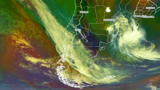
A cold front is set to break the heatwave gripping Rio Grande do Sul, as seen in satellite images on March 7, 2025. This much-anticipated weather change promises to bring relief from the prolonged warmth that has affected the region.
- Cold front observed via satellite imagery
- Weather alerts issued in Argentina and Chile
- Strong winds recorded in Punta Arenas
- Temperature drop expected across southern regions
- Severe storms forecasted for La Pampa
- Cold front to end heatwave in Rio Grande do Sul
Cold Front Approaches Rio Grande do Sul, Ending Heatwave Conditions
How will this cold front change the weather in Rio Grande do Sul? Satellite images reveal a cold front advancing from the Pacific, promising to bring much-needed rain and cooler temperatures to the region. As the front moves in, residents can expect a significant drop in temperatures and the end of the oppressive heat.
Impact of the Cold Front on Weather Patterns in South America
The cold front is not just a local phenomenon; it has broader implications for weather across South America. As it moves through the region, it will bring storms and rain, particularly in Patagonia and parts of Argentina. The system is expected to reach Buenos Aires and then move into Uruguay, eventually affecting the southern border of Brazil.
Key Features of the Cold Front and Its Effects
This cold front is characterized by several important features:
- Strong winds reaching up to 72 km/h in affected areas.
- Significant temperature drops, with highs expected to fall below 10°C.
- Heavy rainfall, particularly in southern Argentina and Uruguay.
- Potential for severe thunderstorms and weather alerts in multiple regions.
What to Expect as the Front Moves Through
As the cold front progresses, residents should prepare for changing conditions. Rain and wind will intensify, especially in the late hours of Friday and into Saturday. By Sunday, the front will reach Rio Grande do Sul, bringing with it a chance of strong gusts and cooler temperatures, signaling the end of the heatwave.
In conclusion, the arrival of this cold front is a welcome change for those suffering from the heat in Rio Grande do Sul. As it sweeps through, it will not only cool down the region but also alter weather patterns across South America, making it a significant event to watch.