A major storm is set to enter California and the West Coast on Wednesday, bringing rain and mountain snow. The system will then move into the central and eastern united states late this week, potentially causing severe weather, including tornadoes, high winds, and blizzard conditions in some areas.
- Major storm entering California midweek
- Severe weather outbreak expected in Midwest
- Tornadoes and high winds are potential threats
- Winter Storm Marisol impacting mountain regions
- Rain and snow forecast from Wednesday to Saturday
- High winds could cause fire danger
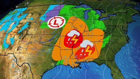
This upcoming storm system is expected to bring substantial precipitation to California from Wednesday through Thursday. Rainfall could lead to localized flooding in recent burn areas, while the Sierra Nevada mountains are forecasted to receive between 1 to 4 feet of snow. By Friday, the storm will begin affecting regions across the central U.S., particularly impacting states such as Iowa, Illinois, Arkansas, Louisiana, Mississippi, and eastern Texas with severe thunderstorms likely.
The potential for severe weather includes risks of tornadoes, damaging winds exceeding 60 mph in some locations, large hail, and flash flooding from heavy rainfall. Areas at greatest risk for severe storms on Saturday include Louisiana, Mississippi, Alabama, Georgia, Tennessee, Kentucky as well as parts of the Midwest. Meteorologists caution that exact details regarding storm intensity and geographic coverage may change as forecasts evolve over the coming days.
The northern side of this storm has been designated Winter Storm Marisol by The Weather Channel. It is anticipated that blizzard conditions could develop in parts of North Dakota and western Minnesota due to strong winds combining with snowfall late Friday into Saturday. Gusty winds accompanying this system will also create a high fire danger across southern High Plains regions.
This storm presents significant risks ranging from heavy snowfall in mountainous regions to severe thunderstorms further south. Residents along its path should remain vigilant as conditions are expected to evolve rapidly throughout the week.