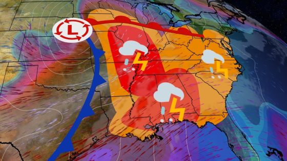
A powerful low-pressure system is set to cause severe weather across the Midwest, South, and East of the united states starting Friday, March 12, 2025. The National Oceanic and Atmospheric Administration (NOAA) warns of potential tornadoes, damaging winds, large hail, and flash flooding as the storm progresses over several days.
- Friday's severe weather includes tornado threats.
- Midwest, South, and East face storm risks.
- Severe storms expected Friday through Sunday.
- Deep South has highest risk Saturday.
- Damaging winds and hail are major concerns.
- Classic spring setup with jet stream influence.
The impending severe weather outbreak will unfold over three days as a strong low-pressure system moves eastward into central and eastern states. The NOAA has identified regions in red on their maps that indicate heightened risks for severe storms. Areas such as St. Louis, Paducah in Kentucky, Memphis and Nashville in Tennessee are under significant threat on Friday evening.
Key details include:
- Severe weather expected from Friday through Sunday.
- Tornadoes potentially reaching EF2 strength or higher.
- Damaging wind gusts and large hail are also concerns.
The storm’s intensity may vary based on atmospheric conditions leading up to each day’s events. On Saturday, the Deep South will face heightened risks with potential supercell thunderstorms affecting Alabama, Georgia, Louisiana, Mississippi, Tennessee, and parts of Florida. By Sunday morning into afternoon hours, additional storms could develop across mid-Atlantic states including Charleston and Washington D.C., maintaining threats of damaging winds and isolated tornadoes.
This multi-day severe weather event highlights typical springtime conditions characterized by a dramatic plunge in the jet stream coupled with increased moisture from the Gulf of Mexico. As these elements converge over land areas already primed for thunderstorms, residents in affected zones should remain vigilant for alerts regarding tornado watches or warnings during this period.