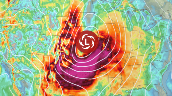
On March 12, 2025, an atmospheric river-fueled storm began impacting the West Coast of the united states, prompting evacuations in Southern California. The storm poses significant risks including mudslides, flooding, and severe weather conditions as it moves eastward across the country.
- Atmospheric river storm impacts Southern California.
- Evacuations ordered for vulnerable properties.
- Severe thunderstorms and tornado risks increase.
- Heavy snow expected in Sierra Nevada mountains.
- Central US faces fire weather risk.
- East Coast to experience wet, stormy conditions.
The incoming storm has already resulted in evacuations for about 120 homes near vulnerable burn scars in Los Angeles County. State agencies have mobilized over 400 personnel to prepare for emergency responses. Rainfall is expected to intensify overnight into Thursday, especially threatening areas affected by previous wildfires.
Key details include:
- A level 2 of 4 risk of flooding rainfall from Santa Barbara to Los Angeles.
- Evacuation orders are active for regions near the Palisades and Eaton fire burn scars.
- Warnings urge residents in these areas to be ready for immediate evacuation if necessary.
The storm will strengthen as it travels eastward into the Plains, bringing severe thunderstorms and possible tornadoes. Wind gusts may reach up to 75 mph in some areas, creating hazardous travel conditions. Residents should remain vigilant as nighttime storms could increase risks significantly due to reduced visibility during severe weather events.
This powerful storm system not only threatens California but also poses a significant risk across various states as it progresses through the week. Authorities are urging preparedness as conditions evolve rapidly with potential life-threatening weather events on the horizon.