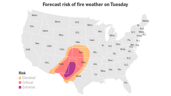
A new wave of wildfire danger is expected to impact the southern and central Plains this week. Forecasts indicate that strong winds, coupled with dry conditions, will elevate fire risks across Texas, Oklahoma, Kansas, and Missouri starting Monday.
- New wildfire danger in southern Plains
- Winds forecasted at 25-35 miles per hour
- Gusts over 40 mph expected in some areas
- Dry conditions due to recent cold front
- Humidity levels dropping below 20 percent
- High winds complicate firefighting efforts
The Storm Prediction Center reports widespread winds of 25 to 35 miles per hour, with gusts potentially reaching over 40 miles per hour in certain areas. Meteorologist David Roth highlighted that low humidity levels and high temperatures will further exacerbate the fire risk.
This week marks a critical period for wildfire risks in the southern and central Plains as dry air continues to dominate the region. The combination of high temperatures rising into the 60s and 70s along with relative humidities dropping below 20 percent creates an environment conducive to wildfires.
Key details include:
- Winds of 25-35 mph are forecasted, with gusts exceeding 40 mph.
- Humidity levels may drop into the teens or single digits.
- Fire spread can accelerate significantly; a fire can move one mile each day for every additional ten miles per hour of wind speed.
The recent cold front has pushed moisture away from Texas while offshore winds have kept conditions dry. As a result, little moisture is expected to return on Monday. This lack of moisture combined with increasing temperatures raises alarms for firefighters who may struggle to control any fires that ignite under these conditions.
The upcoming days pose significant challenges for managing wildfire risks in affected areas. With both wind strength and low humidity contributing factors, officials urge residents to stay informed about local advisories regarding fire safety measures.


![Will Avalanche [AVAX] Plunge Further? Bears Set Sights on $14.5 Support!](https://news.faharas.net/wp-content/uploads/2025/03/Will-Avalanche-AVAX-Plunge-Further-Bears-Set-Sights-on-145.webp.webp)