A severe weather threat is forecasted to impact the Midwest and South this weekend, starting Saturday night into Sunday. A low pressure system moving from the Northern Rockies will bring a cold front that may trigger severe storms across several states, including Texas and Tennessee.
- Severe weather threat for Midwest and South
- Cold front may spark storms Saturday night
- Large hail possible in eastern Kansas area
- Sunday's threat shifts to eastern Texas-Tennessee
- Less instability than previous severe outbreak
- SPC monitoring potential since March 17
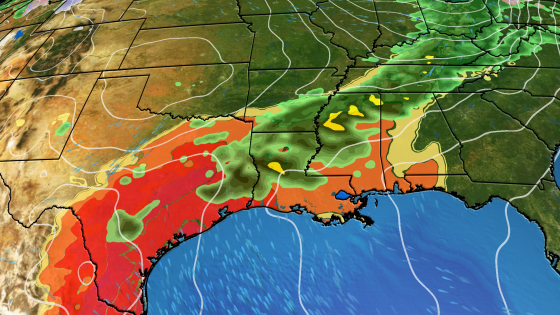
This upcoming weekend marks the first significant severe weather threat of spring 2025. The National Oceanic and Atmospheric Administration (NOAA) has identified areas at risk for thunderstorms, particularly from eastern Kansas through northern Missouri on Saturday night. Although not projected to be as widespread as last weekend’s outbreak, there remains a possibility of large hail and damaging winds.
The severe storm threat will shift southward on Sunday, affecting regions from eastern Texas to Tennessee. The Storm Prediction Center (SPC) warns that while conditions are less favorable than previous outbreaks, isolated tornadoes cannot be ruled out. Key details include:
- Timing: Peak threat from Sunday afternoon to early Monday.
- Areas affected: Lower Mississippi Valley, including parts of Arkansas and Louisiana.
- Storm characteristics: Potential for damaging winds exceeding 60 mph and large hail.
This weekend’s setup differs significantly from last week’s severe weather event. While SPC began monitoring for this potential on March 17, current atmospheric conditions show less instability and wind shear compared to prior systems. The jet stream’s dip is shallower this time around, which contributes to reduced chances for severe storm development.
The upcoming severe weather threat highlights the importance of preparedness as spring unfolds. Residents in affected areas should remain vigilant and have emergency plans ready as conditions can change rapidly.