The world now has a more detailed map of the seafloor than ever before, thanks to groundbreaking satellite technology. On March 22, 2025, NASA unveiled a stunning video showcasing the depths of the ocean, revealing features previously hidden beneath the waves. Have you ever wondered what lies beneath the surface of our oceans?
- Detailed seafloor mapping achieved via satellite
- SWOT satellite launched by NASA and CNES
- Maps improve submarine navigation safety
- Gravity-based data reveals unseen seafloor features
- Abyssal hills cover 70% of ocean floor
- Ships have only mapped a quarter of oceans
NASA’s Satellite Technology Transforms Seafloor Mapping for the U.S. and Beyond
How well do you know the ocean floor? Surprisingly, the moon has been mapped more thoroughly than our oceans. With NASA’s Surface Water and Ocean Topography (SWOT) satellite, launched in 2022, researchers are uncovering the mysteries of the deep. This technology is vital for safe navigation and communication in U.S. waters.
Understanding the Ocean Floor: What SWOT Reveals
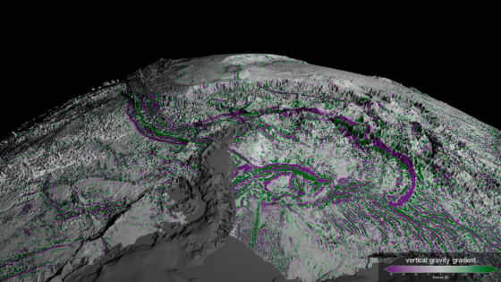
The SWOT satellite is a game-changer for oceanography. It uses gravity-based data to uncover features like abyssal hills and undersea volcanoes that older satellites missed. Here’s why this matters:
- Improves submarine navigation through previously unknown terrains.
- Facilitates the repair of underwater communication cables.
- Reveals the most common landform on Earth, covering 70% of the ocean floor.
- Enhances our understanding of tectonic activity beneath the waves.
How SWOT Maps the Seafloor with Precision
SWOT employs advanced technology to detect subtle gravitational changes caused by underwater features. This allows researchers to create detailed maps that were impossible to achieve with older methods. By observing the sea surface, SWOT can pinpoint the locations of underwater hills and volcanoes, providing insights into Earth’s geology.
The Future of Ocean Exploration: What’s Next?
As research continues, the data from SWOT will lead to even more discoveries about the ocean’s depths. Scientists are excited about the potential for new findings that could reshape our understanding of marine ecosystems and geological processes. What secrets will the ocean reveal next?
In conclusion, NASA’s innovative satellite technology is revolutionizing our understanding of the ocean floor. As we continue to explore these depths, we can expect to learn more about our planet’s hidden features and improve our navigation and communication systems.