Severe storms are forecasted to impact the Midwest, South, and East Coast starting this weekend. The National Oceanic and Atmospheric Administration (NOAA) warns of potential tornadoes, damaging winds, and large hail as the storm system progresses from March 29 through March 31, 2025.
- Severe storms expected in Midwest, South, East.
- Tornadoes, wind, and hail are potential threats.
- Timing: Severe storms start Saturday night.
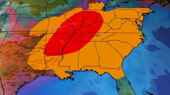
- Widespread severe weather forecast for Sunday.
- Monday's storms may impact East Coast cities.
- Springtime setup involves jet stream and moisture surge.
The upcoming severe weather event is driven by a strong low-pressure system moving from Kansas to New York. This setup will create conditions conducive to supercell thunderstorms as moisture surges northward from the Gulf of Mexico. The storm system is anticipated to bring widespread severe weather starting Saturday evening in the Plains.
Key details include:
- Saturday Night: Large hail and strong wind gusts are expected in northeastern Oklahoma through eastern Kansas and western Missouri.
- Sunday: Severe storms will develop from eastern Texas to the southern Great Lakes with risks of EF2 or higher tornadoes.
- Monday: Storms may reach the mid-Atlantic and Northeast with wind damage being a primary threat.
The timing indicates that severe weather could begin Saturday night but will peak on Sunday afternoon into Sunday night. Residents should prepare for possible overnight alerts as storms move eastward towards populated areas like St. Louis, Indianapolis, Nashville, and eventually reaching cities such as Washington D.C. and New York City on Monday.
This multiday severe weather threat highlights typical spring patterns where a sharp jet stream plunge creates favorable conditions for intense storms. As communities brace for potentially destructive weather events over this weekend into early next week, preparedness remains essential for those in affected areas.