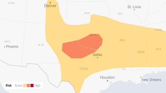
Severe thunderstorms are set to impact the Southern Plains, with forecasters warning of damaging winds, large hail, and potential tornadoes. As of 2025-05-25 18:22:00, the weather outlook indicates heightened risks for central and northeastern Texas and southwestern Oklahoma.
- Severe thunderstorms threatened Southern Plains.
- Damaging winds and large hail expected.
- Tornadoes possible in Texas and Oklahoma.
- Flash flooding risk in central Oklahoma.
- Thunderstorm activity continues into Monday.
- Spring storms typical for lower Great Plains.
The Storm Prediction Center has issued a level 3 out of 5 risk for severe weather, predicting hail up to three inches and winds reaching 80 miles per hour. As storms move eastward, the lower Mississippi Valley and Deep South may also experience severe conditions into the night.
What does this mean for residents in these areas? The potential for severe weather raises concerns about safety and property damage. Here are key points to consider:
- Hail larger than baseballs could cause significant damage.
- Tornadoes are possible, particularly in northeast Texas and southwest Oklahoma.
- Flash flooding risks are heightened in central Oklahoma and northwestern Arkansas.
- Storms may continue into Monday, affecting a broader area.
As the storm system progresses, it’s crucial for residents to remain vigilant and prepared. Stay tuned to local weather updates for the latest information.