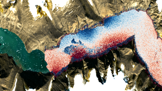
Scientists have recently confirmed the cause of a remarkable seismic event that shook the Earth for nine consecutive days in September 2023. This phenomenon, driven by two colossal “mega-tsunamis,” originated from landslides within East Greenland’s Dickson Fjord.
- First direct observations of mega-tsunamis
- Seismic waves lasted nine days in 2023
- Landslides caused by glacier melting
- SWOT satellite confirmed seiche existence
- New satellite technology enhances ocean monitoring
- Climate change drives extreme ocean phenomena
The mega-tsunamis, one towering at 650 feet (200 meters), resulted from climate change-induced glacier melting. Initially a mystery, the seismic waves were traced back to these waves, thanks to advanced satellite technology. Findings published on June 3, 2025, in the journal Nature Communications, highlight how satellite data can resolve previously unmeasured oceanic phenomena.
What can we learn from these extreme events? Understanding the dynamics of such mega-tsunamis is crucial for predicting future occurrences.
This study raises important questions about the implications of climate change on oceanic stability. How can we better prepare for such extreme events? The research emphasizes the need for innovative approaches in data analysis.
- Climate change is accelerating extreme weather events.
- Satellite technology enhances our understanding of ocean dynamics.
- Future research could improve tsunami prediction models.
As we advance our understanding of these extreme phenomena, leveraging satellite data will be crucial for future oceanographic research and climate resilience strategies.