As summer approaches, many regions are bracing for warm and muggy weather. Today, temperatures are expected to soar into the high 80s before thunderstorms roll in this evening, providing a brief respite before the heat returns. On 2025-06-19 17:09:00, residents should prepare for a shift in conditions as a cold front moves across Lake Erie.
- Warm and muggy day ahead
- Afternoon thunderstorms expected
- Cold front will briefly cool temperatures
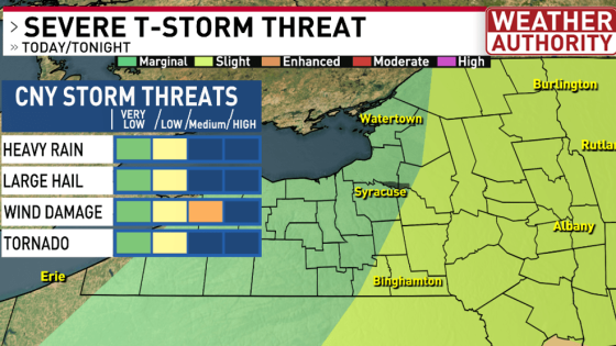
- Severe storms likely in Finger Lakes
- Higher temperatures forecast for next week
- Possible triple digit heat index values
This evening, scattered strong to severe thunderstorms are likely to develop after 3 PM in the Finger Lakes, with Syracuse expecting storms between 4 PM and 7 PM. The Storm Prediction Center has indicated that areas east of I-81 will have a higher chance of experiencing severe weather.
As we look ahead, one key question arises: how will these weather patterns affect daily life? With the first full week of summer approaching, temperatures could spike into the mid-90s, leading to uncomfortable conditions. Consider these points:
- Severe thunderstorms may disrupt evening plans.
- Heat index values could reach dangerous levels next week.
- Humidity levels will fluctuate, impacting comfort.
- Stay updated with local forecasts for safety.
As we prepare for the heat and storms, remember to stay hydrated and keep an eye on local forecasts for updates. Your safety is paramount this summer!