Illegal drone traffic is becoming a growing concern in Belgium, prompting local authorities to take stronger measures. Since 2025-08-05 16:10:00, the Hasselt police have begun scanning the skies to detect unauthorized drone flights. This new initiative aims to enhance airspace security and protect public safety in the region.
- Politie Hasselt scant luchtruim op drones
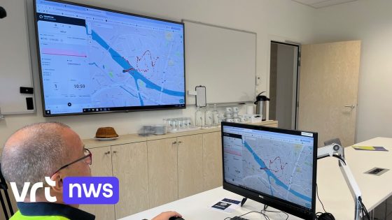
- LRH gebruikt Skeydrone detectiesysteem
- Skeydrone identificeert drone locatie nauwkeurig
- Systeem toont drone vliegroute en ID
- Detecteert ook locatie van dronepiloot
- Doel is illegaal droneverkeer bestrijden
The police zone Limburg Regio Hoofdstad (LRH) is using the advanced dronedetection system from Skeydrone. This technology not only tracks the drone’s location and flight path but also identifies the drone’s unique number and pinpoints the pilot’s position. How effective can this system be in curbing illegal drone activity? And what does it mean for residents and businesses in Hasselt and beyond?
With these questions in mind, here’s a concise overview of the situation and its local impact.
What does this new drone monitoring mean for the community? The system offers a proactive approach to drone regulation, helping authorities respond quickly to potential threats or disturbances. It also raises awareness about responsible drone use. Key points include:
- Real-time tracking of drone flights and pilot locations
- Enhanced ability to enforce drone regulations in Limburg
- Potential reduction in drone-related incidents near sensitive areas
As drone technology advances, will other Belgian cities adopt similar systems? Residents and drone operators alike should stay informed about evolving regulations and embrace responsible flying to ensure safe skies for all.