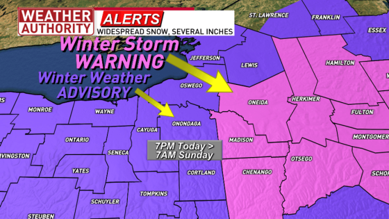
SYRACUSE, N.Y. — A winter storm is expected to bring widespread snow to Central New York (CNY) this evening through the night, with several inches of accumulation by sunrise on Sunday, February 9. Winter Storm Warnings and Winter Weather Advisories will be in effect from 7 PM today until 7 AM Sunday.
- Widespread snow expected across CNY tonight.
- Winter Storm Warnings effective 7pm today.
- Daytime temperatures in the 20s.
- Snowfall accumulation of 3-6 inches forecasted.
- Ice accumulation possible in Pennsylvania.
- Check Weather Authority for updates.
The weather earlier in the day will remain quiet but chilly, with temperatures in the 20s. Light winds are expected, and any morning lake effect flurries will taper off before the arrival of widespread snow between 6 PM and 7 PM.
A large area of low pressure moving into CNY from the west will primarily affect the northern side of the system with snow accumulation. The southern side may experience rain and a wintry mix; however, CNY is set to receive only snow. Areas in Pennsylvania may see some ice accumulation as well.
Snowfall projections indicate that Syracuse and surrounding areas can expect about 3-6 inches overnight. Regions east and south of Onondaga County could see higher totals ranging from 6-9 inches. Key details include:
- Syracuse: Expected snowfall of 3-6 inches
- Finger Lakes Region: Expected snowfall of 3-6 inches
- Areas east/south of Onondaga County: Expected snowfall up to 6-9 inches
The timing for snowfall suggests that it will begin around early evening and continue through early morning hours on Sunday. This storm is part of a larger weather pattern affecting much of the Northeast and New England states, which may also face heavy snow accumulations.
This impending winter storm highlights the need for caution among residents in affected areas as they prepare for significant snowfall overnight into Sunday morning.