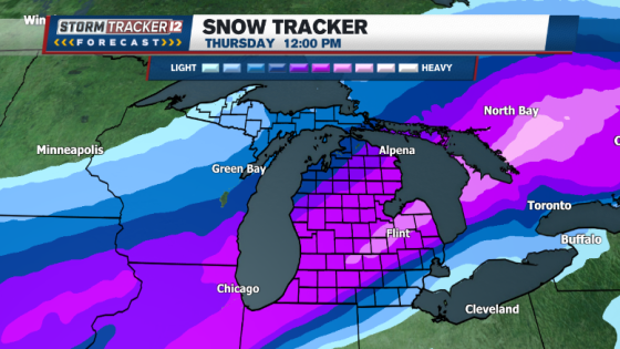
Mid-Michigan is expecting its first major snowstorm of the winter from Wednesday evening into Thursday morning. The Storm Tracker 12 Weather Team has issued Alert Days due to the potential for significant snowfall accumulation in the region.
- First major snowstorm expected Wednesday evening.
- Alert Days issued for significant snow accumulation.
- Snowfall totals still uncertain at this time.
- Heaviest snowfall likely in northern Ohio area.
- Thursday morning commute may be difficult.
- Another snow event possible on Saturday.
The upcoming storm is predicted to follow a path across northern Ohio, which aligns with forecasts indicating that Mid-Michigan could receive heavy snowfall on its north side. Although exact snowfall totals are not yet confirmed, many weather models suggest substantial accumulation is likely.
During this period, temperatures are expected to remain in the low to mid 20s Fahrenheit. This colder air will contribute to drier and lighter snow due to lower moisture content. As a result, roads may become hazardous during Thursday morning’s commute as they could be covered with fresh snow.
- Potential for significant snowfall accumulation in Mid-Michigan.
- Temperatures during the storm will be between 20°F and 25°F.
- Commuters should expect difficult driving conditions on Thursday morning.
Following this winter event, Valentine’s Day on Friday is anticipated to be dry. However, another system may bring additional snow to Mid-Michigan on Saturday. Residents are advised to stay updated with local forecasts as conditions evolve leading up to and during the storm.
This week marks an important shift in winter weather for Mid-Michigan as residents prepare for their first major snowstorm of the season. With careful planning, commuters can navigate what promises to be a challenging travel day on Thursday.