A Winter Storm Warning is set to take effect at 1 PM on Tuesday, February 11, 2025, lasting until 7 AM Wednesday morning. This warning affects several areas, including Montgomery, Howard, Loudoun, and Prince George’s counties in Maryland as well as Washington D.C.
- Winter Storm Warning effective Tuesday 1pm
- NBC4 predicts highest snowfall totals
- FOX5 lowers snow total expectations
- ABC7 forecasts lowest projected snowfall
- WUSA9 includes varying ranges by area
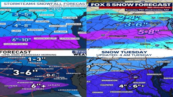
The upcoming winter storm has prompted various forecasts from major News networks regarding expected snowfall amounts. NBC4 predicts the highest totals of between 4 to 8 inches for regions including Montgomery and Howard counties. In contrast, ABC7 offers a more conservative estimate of about 3 to 6 inches for these same areas.
Other networks have adjusted their predictions as well. FOX5 has lowered its forecast to a range of 3 to 6 inches for the affected counties while estimating slightly less snow in Frederick and Carroll counties at around 2 to 4 inches. WUSA9 suggests a general range of up to 6+ inches but limits this prediction primarily to central parts of Montgomery and Loudoun counties.
- NBC4: Predicted snowfall of 4-8 inches in most areas.
- FOX5: Adjusted forecast now at 3-6 inches.
- ABC7: Lowest projection at around 3-6 inches.
- WUSA9: General estimate up to 6+ inches limited to certain regions.
This winter storm is expected to impact travel conditions significantly across the region. Residents are advised to prepare accordingly and stay updated through local weather reports as conditions may change rapidly leading up to the event.
The approaching winter storm poses potential challenges due to varying snowfall predictions across different networks. With warnings issued and forecasts ranging widely, residents should remain vigilant and prepared for changing conditions throughout the duration of the storm warning.