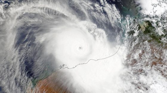
Tropical cyclone Zelia made landfall in Western Australia on February 14, 2025, at 12:30 p.m. local time, with winds reaching 130 mph. The storm struck approximately 30 miles east of Port Hedland, which recorded peak wind gusts of 75 mph and significant rainfall of 17.16 inches over 48 hours, primarily affecting sparsely populated areas.
- Tropical cyclone Zelia made landfall in Australia.
- Zelia was a Category 4 storm at landfall.
- Record rainfall of 17.16 inches reported.
- First major cyclone landfall in 2025.
- Warm ocean temperatures contributed to intensification.
- Decrease in cyclone frequency near Australia noted.
Zelia intensified rapidly before making landfall, reaching peak winds of 150 mph before weakening slightly. The cyclone is notable as it is the fifth named storm of the 2024/2025 Australian tropical cyclone season, which is considered average in terms of activity. The storm’s trajectory allowed it to primarily impact less populated regions, mitigating potential damage to larger communities.
Key details regarding cyclone Zelia include:
- Landfall location: 30 miles east of Port Hedland.
- Peak wind gusts recorded: 75 mph.
- Total rainfall at Pardoo Station: 17.16 inches over 48 hours.
Despite the storm’s strength, the eyewall missed the city of Port Hedland, which has a population of around 15,000. This event is significant as it marks the first major tropical cyclone to impact Australia in 2025, following a relatively quiet start to the cyclone season. The cyclone’s rapid intensification was attributed to record-warm ocean temperatures, which were approximately 1 to 2 degrees Celsius above average, a phenomenon linked to climate change.
In summary, tropical cyclone Zelia’s landfall in Western Australia highlights the ongoing challenges of severe weather events exacerbated by climate change. With significant rainfall and wind speeds, the cyclone serves as a reminder of the increasing intensity of storms in recent years.