Winter Storm Kingston is expected to impact the central and eastern united states beginning February 17, 2025. The storm could develop into a significant nor’easter by February 19, bringing heavy snow and strong winds to various regions.
- Bitter cold air and winter storms persist.
- Winter Storm Kingston expected this week.
- Potential for significant ice and snow.
- Nor'easter impacts mid-Atlantic and Northeast.
- Forecast models indicate growing snow chances.
- Stay updated via weather.com and app.
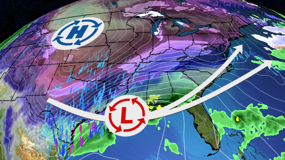
The ongoing winter weather pattern continues as another storm approaches the U.S. This system, named Winter Storm Kingston by The Weather Channel, is anticipated to bring severe weather conditions including snow and ice from north Texas through parts of the Midwest. As it moves eastward, areas in the mid-Mississippi Valley, Ohio Valley, Tennessee Valley, and mid-Atlantic states may experience significant precipitation.
Key details include:
- Snow and ice accumulation expected in northern Texas, Oklahoma, Arkansas, Kansas, and Missouri starting Monday night into Tuesday.
- The storm will spread into the Carolinas by Wednesday with potential for significant ice or snowfall.
- A “heavy snow” threat has been issued for parts of the Northeast from Virginia to Massachusetts on Wednesday and Thursday.
The development of low pressure near the Gulf Coast will track eastward towards the East Coast. Depending on its exact path—closer to or farther offshore—the intensity of snowfall and wind impacts could vary significantly. Current computer models suggest an increasing likelihood of a major nor’easter affecting coastal areas late this week.
This upcoming winter storm highlights ongoing challenges posed by severe winter weather across much of North America. Residents are advised to stay updated on local forecasts as more information becomes available regarding specific impacts in their areas.