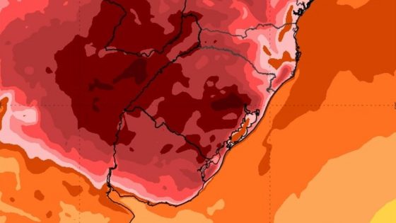
Rio Grande do Sul is bracing for a significant heat wave, with temperatures expected to soar above average in the coming days. This trend, highlighted in weather maps with dark red hues, indicates a new wave of extreme heat starting February 28, 2025. Are you ready for the heat?
- Rio Grande do Sul experiencing above-average temperatures.
- New heatwave expected to start February 28.
- Areas near Porto Alegre will be hottest.
- Temperatures may exceed 40ºC in some regions.
- High pressure systems influencing weather patterns.
- Clear skies and high solar incidence expected.
Rio Grande do Sul Faces Extreme Heat Wave: What to Expect
As the heat wave approaches, residents may wonder how it will impact daily life. With temperatures rising significantly, it’s essential to stay informed and prepared.
Key Areas Affected by the Heat Wave in Rio Grande do Sul
The upcoming heat wave is expected to impact several regions more severely. Key areas include:
- Metropolitan Porto Alegre
- Vales do Rio Pardo and Taquari
- Central and Northern regions
- Western territories of Rio Grande do Sul
Understanding the Causes of the Heat Wave in Rio Grande do Sul
This intense heat is driven by two high-pressure systems. One is over the continent, while the other approaches from the ocean. These systems create a downward air movement, preventing cloud formation and leading to clear skies. This results in concentrated heat near the surface, making conditions ripe for soaring temperatures.
Daily Temperature Forecast for the Heat Wave
Here’s a quick look at the expected temperatures over the next few days:
- February 28: Highs around 36ºC to 38ºC.
- March 1: Temperatures could reach near 40ºC.
- March 2: Many areas likely to exceed 40ºC.
- March 3: Widespread highs above 40ºC.
- March 4: Continued extreme heat, especially in the Fronteira Oeste.
- March 5: Heat may start to decline with a new cold front approaching.
As the heat wave unfolds, residents should remain vigilant and take necessary precautions to stay safe. With temperatures rising, it’s crucial to stay informed and prepared.