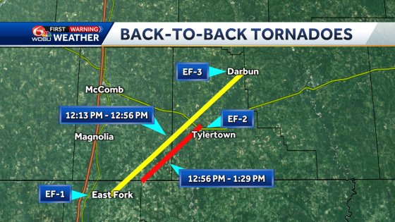
On March 16, 2025, two tornadoes formed just minutes apart, tracing nearly the same path through Louisiana and Mississippi. The Kentwood to Darbun tornado was rated EF-3, while the Tylertown tornado received an EF-2 rating. How do such events unfold so closely together, and what impact do they have on communities?
- Two tornadoes formed minutes apart.
- Kentwood-Darbun tornado rated EF-3.
- Tylertown tornado initially rated EF-2.
- Both tornadoes took nearly identical paths.
- Debris signatures confirmed tornado activity.
- Tornadoes typically vary in strength over time.
Two Tornadoes Hit Louisiana and Mississippi in Rapid Succession
How often do two tornadoes form so closely together? This rare event unfolded in Louisiana and Mississippi, showcasing the incredible power of nature. Meteorologists noted that the first tornado, tracking from Kentwood to Darbun, reached EF-3 strength, while the second tornado near Tylertown was rated EF-2. Both tornadoes took a similar path, raising concerns for residents in the area.
Understanding Tornado Ratings and Their Impact
The tornadoes that struck on March 16 were part of a supercell thunderstorm system, which often produces varying tornado strengths. The Kentwood-Darbun tornado initially registered as an EF-1 before intensifying to EF-3. The Tylertown tornado began as an EF-2. This fluctuation in strength is typical for tornadoes formed from supercells, which often start weak, gain strength, and then dissipate.
- First tornado rated EF-3 due to severe damage.
- Second tornado rated EF-2, indicating less intensity.
- Both tornadoes occurred within minutes of each other.
- Similar paths raised concerns for local residents.
The Meteorological Significance of Dual Tornado Events
When two tornadoes form in such close succession, it raises questions about the atmospheric conditions that allow this to happen. Meteorologists believe that the supercell structure of the storm contributed to the formation of both tornadoes. The initial tornado’s debris signature indicated severe winds, while the second tornado exhibited classic signs of rotation, confirming its presence.
Community Impact and Recovery Efforts
The impact of these tornadoes on local communities can be devastating. Unfortunately, three lives were lost in the Darbun area due to the EF-3 tornado. In the aftermath, recovery efforts will focus on assessing damage, providing aid to affected residents, and ensuring that the community is prepared for future storms. Residents are encouraged to stay informed and have emergency plans in place.
In conclusion, the March 16 tornadoes highlight the unpredictable nature of severe weather in the U.S. As communities recover, it’s essential to prioritize safety and preparedness for the future.


![Will Avalanche [AVAX] Plunge Further? Bears Set Sights on $14.5 Support!](https://news.faharas.net/wp-content/uploads/2025/03/Will-Avalanche-AVAX-Plunge-Further-Bears-Set-Sights-on-145.webp.webp)

