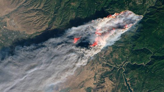
The first satellite of the Google-backed FireSat constellation successfully made it to orbit on March 14, 2025. This groundbreaking achievement marks a significant step forward in wildfire detection and monitoring. With wildfires becoming an increasing threat, how can technology help US combat this crisis?
- FireSat constellation launched first satellite.
- Over 50 satellites planned for monitoring.
- Initial phase includes three satellites.
- High-resolution imagery for wildfire detection.
- Joint effort by Muon Space and nonprofits.
- Near real-time updates for firefighters.
FireSat Constellation Launches to Enhance Wildfire Detection Across the Globe
What if we could detect wildfires before they spread? The FireSat constellation, with its first satellite now in orbit, promises to do just that. This innovative technology will allow for rapid updates on wildfire activity, helping firefighters respond more effectively and save lives.
How FireSat Will Transform Wildfire Monitoring in the U.S.
The FireSat constellation is designed to provide high-resolution imagery of wildfires, addressing the limitations of current monitoring methods. Here’s how it will make a difference:
- Real-time updates on fire locations and behavior.
- High-resolution five-meter imagery for better analysis.
- Frequent revisits to every point on Earth, enhancing data accuracy.
- Collaboration with organizations like the Environmental Defense Fund for effective deployment.
What Makes FireSat Different from Existing Wildfire Tracking Methods?
Current wildfire tracking often relies on aerial photography or low-resolution satellite images, which can be costly and inefficient. FireSat changes the game by using advanced multispectral infrared cameras tailored for wildfire detection. This technology enables:
- Improved accuracy in identifying fire hotspots.
- Faster response times for firefighting teams.
- Enhanced data collection for better understanding of fire behavior.
The Future of Wildfire Management with FireSat
As the FireSat constellation grows to include over 50 satellites by 2026, its impact on wildfire management will be profound. This technology will not only assist firefighters but also contribute to environmental conservation efforts by monitoring fire patterns and their effects on ecosystems.
In conclusion, the successful launch of the FireSat satellite signals a new era in wildfire detection. With its ability to provide timely and accurate information, it holds the potential to save lives and protect communities from the devastating effects of wildfires.


![Will Avalanche [AVAX] Plunge Further? Bears Set Sights on $14.5 Support!](https://news.faharas.net/wp-content/uploads/2025/03/Will-Avalanche-AVAX-Plunge-Further-Bears-Set-Sights-on-145.webp.webp)