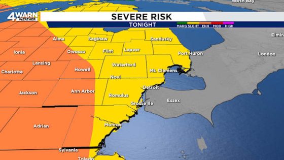
Severe thunderstorms are expected tonight across much of lower Michigan, with the potential for tornadoes. The Storm Prediction Center has issued an Enhanced Risk (level 3) for parts of Metro Detroit, including Howell and Ann Arbor, indicating a serious weather threat.
- Tornado risk tonight in lower Michigan
- Enhanced Risk for Metro Detroit thunderstorms
- Timing: 10 p.m. to 3 a.m.
- Possible large hail and strong winds
- Sunshine expected Friday morning
- Download the 4Warn weather app
Timing for these storms is projected between 10 p.m. and 3 a.m., with the most intense activity likely around midnight. Residents should prepare for large hail, winds exceeding 75 mph, and the possibility of isolated tornadoes. By early Friday morning, the storms will dissipate, leaving behind sunny skies and temperatures in the mid-80s.
This weather event raises concerns about safety and preparedness. Are you ready for potential severe weather? It’s crucial to stay informed and have a plan in place. Key points to consider include:
- Monitor local weather updates regularly.
- Have an emergency kit ready, including food, water, and first aid supplies.
- Know your safe locations in case of tornado warnings.
Stay alert and ensure you have the latest weather information. Download the 4Warn weather app for real-time updates and safety alerts.