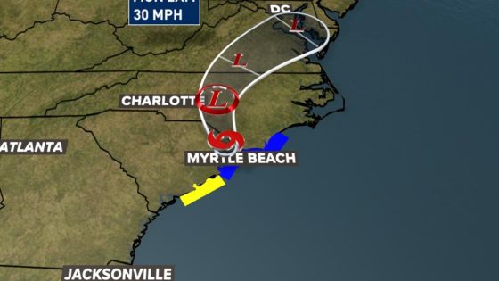
Tropical Storm Chantal has made landfall in South Carolina, impacting the Midlands with gusty winds and rainfall. As the storm pushes inland, residents should remain vigilant through Sunday, July 6, 2025.
- Mild impacts expected for the Midlands
- Tropical Storm Chantal made landfall in SC
- Maximum sustained winds at 50 mph
- Rainfall totals of 1 to 2 inches
- Coastal areas face dangerous rip currents
- Stay informed and prepared for updates
The storm is currently producing maximum sustained winds of 50 mph and is moving north at 8 mph. With a Weather Impact Alert in effect, the Midlands can expect light to moderate rain and wind gusts ranging from 30 to 35 mph.
What does this mean for residents? While the storm’s impacts are expected to be mild in the Midlands, preparation is key. Will you be ready for potential flooding or power outages?
- Rainfall totals could reach 1-2 inches, especially in the northeastern Midlands.
- Minor flooding is possible in low-lying areas.
- Coastal regions may experience wind gusts over 45 mph.
As conditions improve by Sunday evening, it’s crucial to stay updated and heed local advisories. Prepare now to ensure safety during this storm and the rest of hurricane season.