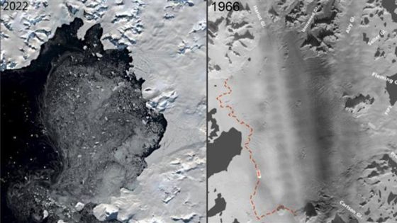
Researchers from the University of Copenhagen are using decades-old aerial photos to enhance our understanding of Antarctic ice shelf collapse. This groundbreaking study, published on November 28, 1966, sheds light on the critical relationship between ice loss and sea level rise.
- Researchers found decades-old aerial photos
- Photos aid understanding of Antarctic ice collapse
- Wordie Ice Shelf significantly retreated since 1980s
- Ronne and Ross shelves pose greater risks
- Melting primarily driven by rising sea temperatures
- Study emphasizes urgency to reduce emissions
The historical images, captured during an American flight over the Antarctic Peninsula, provide a unique dataset that reveals the gradual disintegration of the Wordie Ice Shelf. Once covering 2,200 square kilometers, this ice shelf has significantly retreated since the late 1980s, contributing to rising sea levels. How might these findings influence climate action strategies moving forward?
This research raises an important question: How can we better predict ice shelf behavior in the face of climate change? The findings suggest that the collapse process may be slower than previously thought, which could alter our understanding of imminent sea level threats. Key points include:
- Rising sea temperatures are the main cause of melting beneath ice shelves.
- Historical data helps refine computer models for predicting sea level rise.
- Longer collapse processes may complicate reversal efforts.
As we advance scientific understanding of ice dynamics, prioritizing climate action is essential. The insights from this research could play a pivotal role in shaping future strategies to combat climate change.